
Best Motorcycle Roads in Colorado
Colorado puts more paved road above 10,000 feet under your wheels than any other state, and that altitude shapes everything about riding here. Mountain passes that are genuinely narrow and exposed, afternoon thunderstorms that roll in without much warning, wildlife that steps onto the road at any hour, and air thin enough to affect your judgment and your engine—these are the conditions you plan around, not away from. Get the timing right, pack layers even in July, and you'll find a concentration of high-country riding that's hard to match anywhere else on the continent.
- Routes
- 2
- Best season
- Late May–mid-October
- Helmet law
- Under 18 only; eye protection required all ages
- Lane filtering
- Legal (stopped traffic, ≤15 mph)
- Signature terrain
- High-alpine passes, 10,000–12,000+ ft
The routes
scenic road · colorado
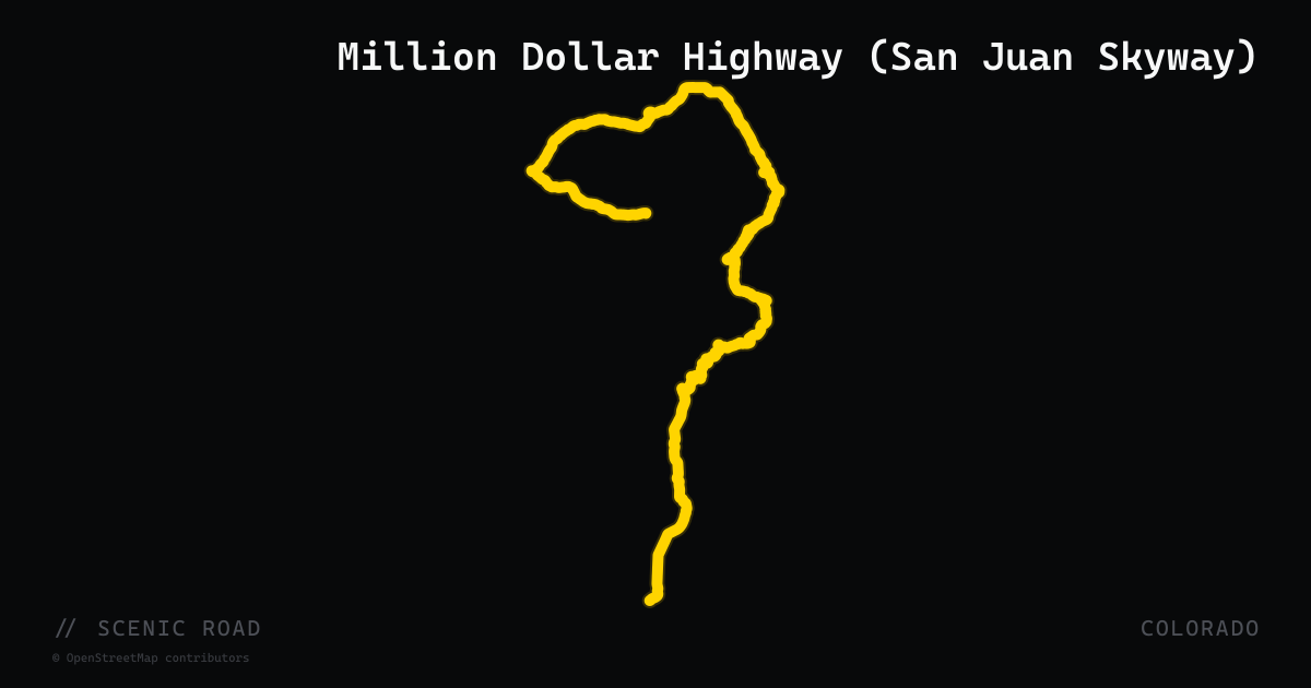
Million Dollar Highway (San Juan Skyway)
The 25-mile Ouray-to-Silverton run of US-550 — no guardrails, mining-camp hairpins over Red Mountain Pass, and the centerpiece of the San Juan Skyway scenic byway loop.
scenic road · colorado
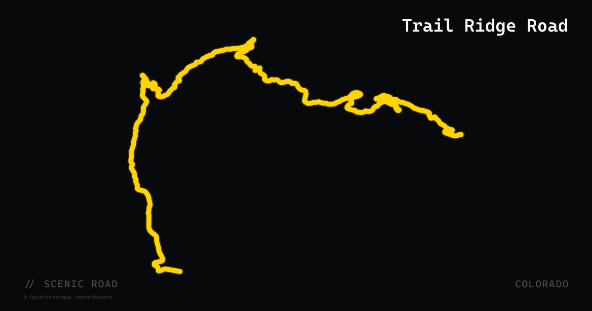
Trail Ridge Road
43 miles of US-34 across Rocky Mountain National Park — the highest continuous paved road in North America, topping out at 12,183 ft above tree line.
Why Colorado Rewards Careful Planning
No other state stacks paved road this high. Colorado has multiple routes crossing above 12,000 feet, and that altitude sets the terms for every ride. Before choosing which roads to string together, understand what you're working with.
Choosing Between Routes
The rides on this page divide roughly into two categories: loops and corridors in the San Juan Mountains (southwestern Colorado, anchored around Ouray, Silverton, and Durango) and Front Range access roads (the central Rockies, reachable as day rides from the I-25 corridor). These are different trips requiring different logistics.
The San Juan routes—including the Million Dollar Highway and the broader San Juan Skyway loop—justify a multi-day stay. Durango or Ouray work well as base towns. The Front Range passes, including Trail Ridge Road and Independence Pass, are closer to population centers but attract heavier tourist traffic mid-summer.
Seasonal and Closure Realities
The higher the road, the shorter its season. Trail Ridge Road and Independence Pass are both closed roughly mid-October through late May, with exact dates shifting year to year based on snowpack. The Million Dollar Highway stays open year-round but is subject to avalanche closures in winter and early spring—check CDOT's travel information line before committing to it in shoulder months.
For adventure riders considering the Colorado Backcountry Discovery Route (COBDR), the window narrows further: July through September only, with multiple crossings above 12,000 feet and at least one significant water crossing on the Hagerman section.
Practical Hazards to Know
- Afternoon thunderstorms are the daily reality in summer. Plan to be off exposed ridgelines by early afternoon.
- Wildlife is present on every route—elk, deer, bighorn sheep, and bear crossings are routine, not rare.
- Temperature swings are severe. A 40°F difference between a valley floor and a 12,000-foot summit is normal. Carry cold-weather gear regardless of the forecast.
- Road debris—sand, gravel, and rockfall—is common on high switchbacks, especially early in the season after snowmelt and road maintenance.
- Timed-entry permits are required for Rocky Mountain National Park during peak season. Check ahead; they sell out.
Gear and Bike Considerations
High altitude reduces engine output noticeably on carbureted bikes. Fuel-injected machines handle the transition better, but riders on older bikes should be aware. Water crossings on the COBDR's Hagerman section require preparation—it is not passable on street-only tires during high runoff. If your trip is pavement-only, any capable street or touring bike works well, though narrower tires make loose gravel on unpaved pass approaches more demanding.
Frequently asked
Do I have to wear a helmet to ride in Colorado?+
Colorado requires helmets only for riders and passengers under 18 years of age. Adults 18 and older are not legally required to wear one, though safety professionals strongly recommend it. All riders regardless of age must wear adequate eye protection—goggles, glasses, or a face shield. A windshield alone does not satisfy the eye-protection requirement under Colorado law.
Is lane filtering legal in Colorado?+
Yes. As of August 7, 2024, lane filtering is legal in Colorado. Riders may pass between stopped vehicles—only when surrounding traffic is at a complete stop—at 15 mph or less, on the left side only, in lanes wide enough to pass safely. Lane splitting (passing through moving traffic) remains illegal. The law carries a sunset provision and is currently set to expire September 1, 2027, pending a CDOT safety review.
When does Trail Ridge Road open and close each year?+
Trail Ridge Road (US-34 through Rocky Mountain National Park) is typically closed from mid-October to late May, with exact dates depending on snowpack and weather. A timed-entry permit is required during summer and fall peak periods. Check the National Park Service website for current conditions before heading out—closures can happen quickly in any season above tree line.
When does Independence Pass open and close?+
Independence Pass (CO-82) is Colorado's highest paved state highway at 12,095 ft and is generally closed from late October or early November through approximately Memorial Day. Opening dates shift year to year based on snowpack. Vehicles over 35 feet are prohibited year-round.
What are the biggest real hazards on Colorado mountain roads?+
Altitude is the first one most riders underestimate—engine performance drops, and physical fatigue sets in faster above 10,000 feet. Afternoon thunderstorms can appear in under 30 minutes; check the forecast and plan to be off exposed ridgelines by early afternoon. Wildlife crossings are common on nearly every mountain route. On roads like the Million Dollar Highway, narrow lanes with no guardrails mean there is no margin for a target-fixation error. Sand and gravel from road crews, especially in spring, can be present on high-pass switchbacks throughout the season.
What's the status of Mt. Blue Sky (formerly Mt. Evans Scenic Byway)?+
The Mt. Blue Sky Scenic Byway is closed through 2025 for federal road repair work. Reopening is targeted for summer 2026, but confirm current status with the U.S. Forest Service before planning a visit.
When to ride
The practical riding window for Colorado's mountain roads runs from late May through mid-October, though the exact dates shift with snowpack each year. Memorial Day weekend through mid-October is the most reliable window, with high-altitude passes often remaining closed into June depending on the prior winter's snowfall. September is widely regarded as the sweet spot—drier weather patterns, thinner crowds, and aspen color in the high country.
+Sources & references (8)
- Colorado Motorcycle Helmet Laws: Rider's Guide — Ramos Law
- Motorcycle Laws — Colorado State Patrol
- Lane Filtering in Colorado — Colorado State Patrol
- Motorcycle Lane Filtering — Colorado Department of Transportation
- The Million Dollar Highway: Complete Motorcycling Guide — Ride to Food
- Colorado's Best Seasonal Roads for Motorcyclists — Ride to Food
- Good For You To Know — Motorcycle Colorado
- The Dos and Don'ts of Colorado's New Lane-Filtering Law — American Motorcyclist Association